
What is GIS!
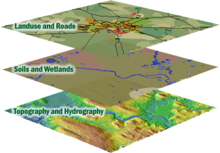
GIS is a method of using computer systems to collect, organize, manipulate and display geographic data to answer questions about the world. It is a system designed to combine many different types of geographic features and analyze the relationships between them in a single framework.
GIS technology provides a method for students to ask important questions about such diverse things as exotic species, transportation planning, climate change and visitor impact in National Parks. The applications of GIS are nearly limitless, encompassing nearly every scientific discipline and many of the humanities. The best way to learn about what GIS can do is to read GIS case studies and look at maps compiled using GIS techniques. The ESRI map book gallery is a great resource for map examples.
For more information or to find out how you can use GIS in your research please contact Carol Cady.
For more detailed information on GIS try GIS.com or the GIS Lounge. The USGS also has an excellent site describing GIS.